
Description
Navionics®+ – NAUS012R | microSD™/SD™
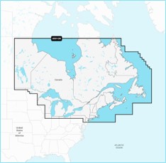
Detailed coverage of the Atlantic and Pacific coasts, inland lakes and waterways of Alaska and Canada (except YT and NU). Coverage includes the Aleutian Islands, Vancouver Island, Puget Sound, the St Lawrence River, the Maritime Provinces and the Grand Banks.
INTEGRATED MAPPING FOR A WIDE RANGE OF CHARTPLOTTERS
A comprehensive, all-in-one solution, Navionics+ charts and maps combine clear, reliable coastal/inland content with advanced guidance features and compatibility with a wide range of chartplotter brands.
Navigate with our best offshore and inland lake coverage for your compatible chartplotter1.
See it your way. Customise your view with various chart layers and overlay combinations.
With your included 1-year subscription, access daily updates via the Navionics® chart installer software.
Advanced route guidance technology2 lets you navigate with suggested dock-to-dock routings.
Selectable map options let you highlight shallow areas, adjust contour density or select a fishing range.
Save money — while continuing to access daily updates plus new content downloads — by renewing your subscription3.